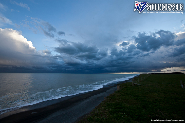
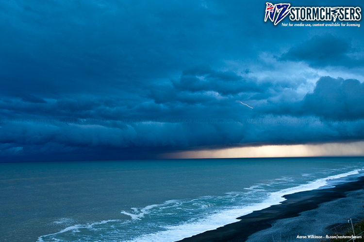
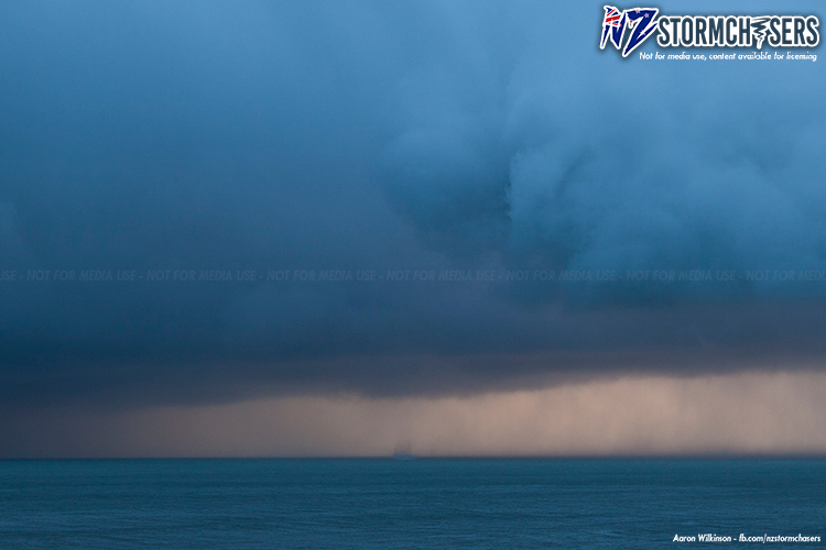
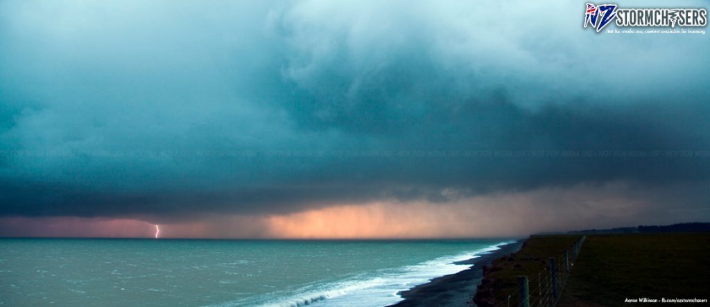
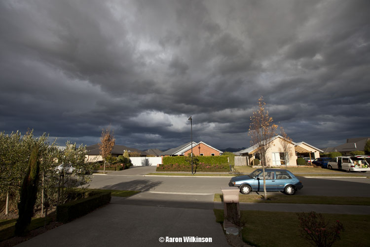
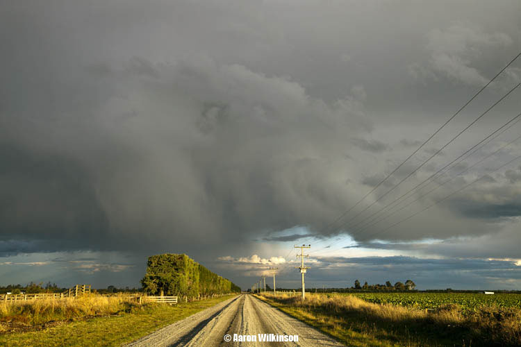
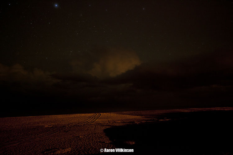
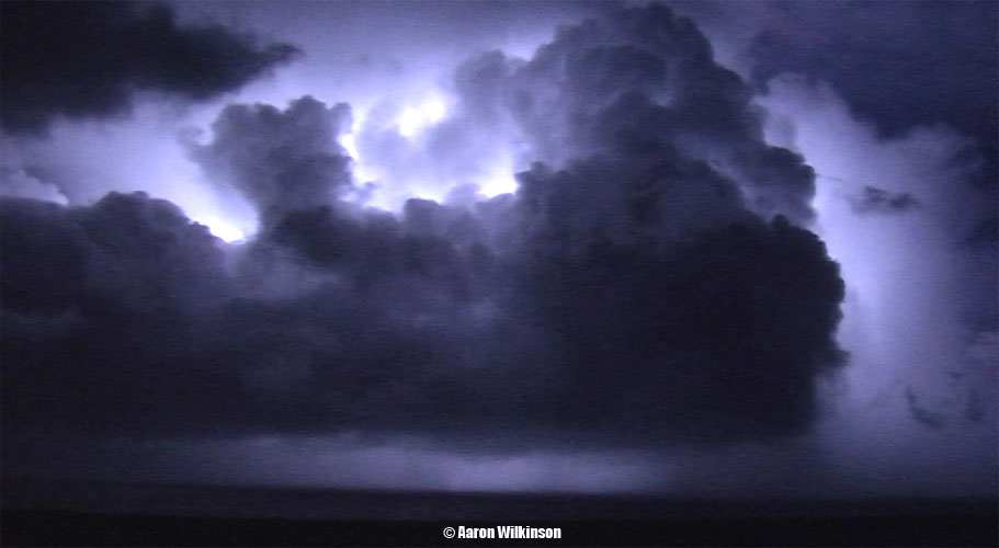
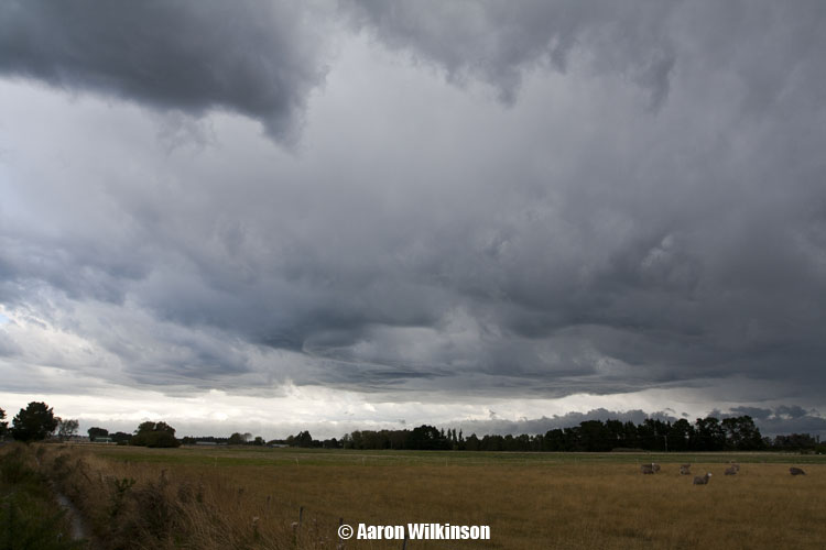
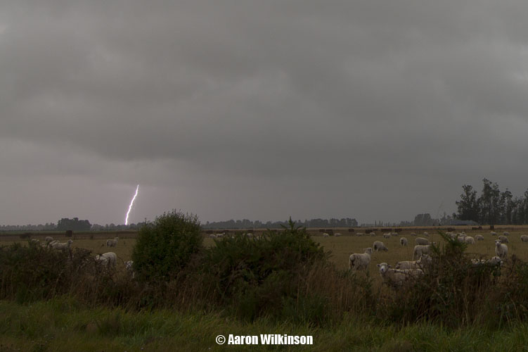
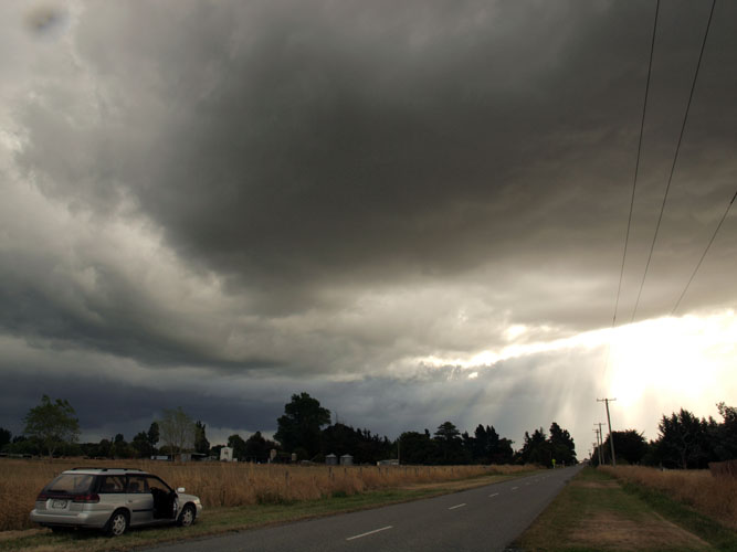
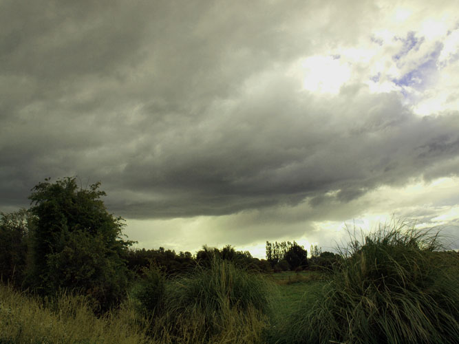
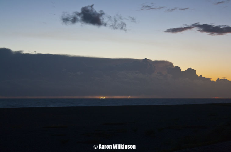
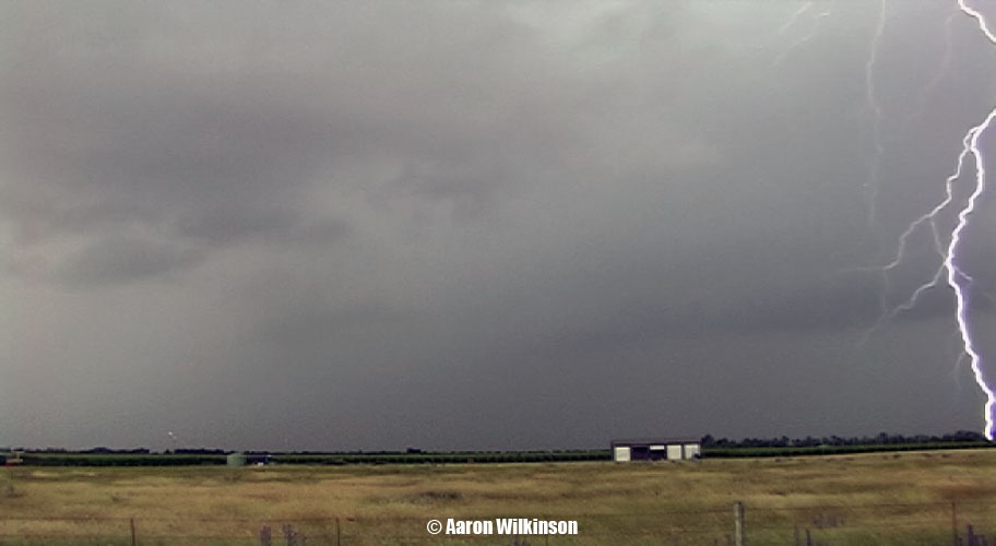
This day we observed a storm moving up the coast from the Ashburton River mouth, we sighted a waterspout forming offshore and various lightning strikes.
As the circulation that was the water spout came onto land it went over the top of Steven Burrows car and violently chugged the car up and down nearly flipping it, thankfully this area of circulation then dissipated. A bit too close to the storm perhaps!
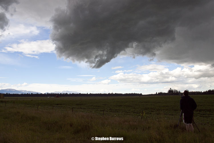
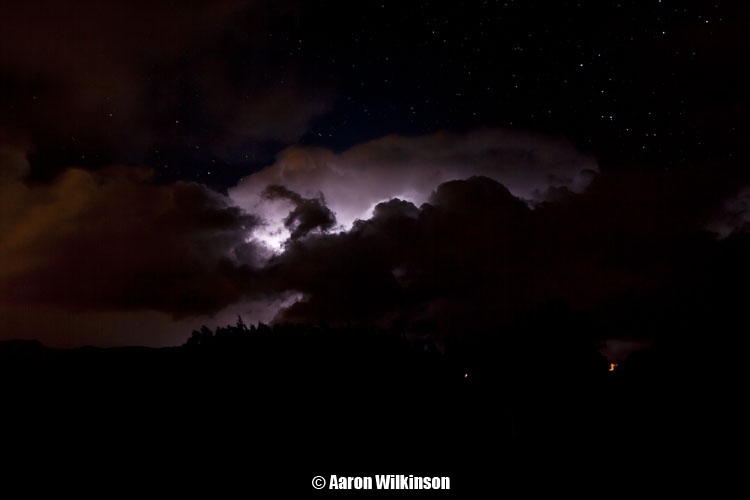
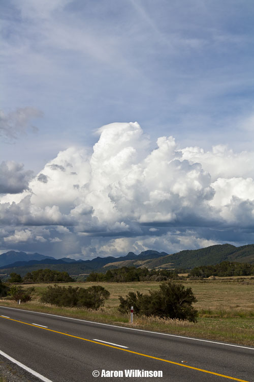
The last of the 3 photo’s below shows the circulation that is the waterspout in the middle in the distance, if you go up on an angle slightly to the right you can see the circulation in the cloud above, not the pointy cloud, more the broader round smooth one just to the left of the pointy cloud.
I better get some more reports up, it’s only been nine years since I last put a report up so not all that long??? lol!!!
I work as a weather forecaster these days for Weatherwatch.co.nz and have done so for quite a while now, juggling my interest for storms / writing storm reports on here and my day to day job has been a bit of an issue for a while but I think the time is right to start chugging out some reports on this site again. I’ve still chased storms whenever I could, I just haven’t put the reports / photos up till now.
I’ve got a fair few to go, the last 9 years worth! I won’t be able to remember all the details about some of the following chases but I’ll let the photos do the talking 🙂
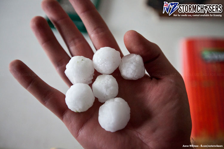
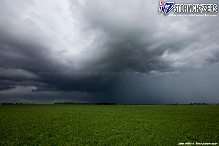
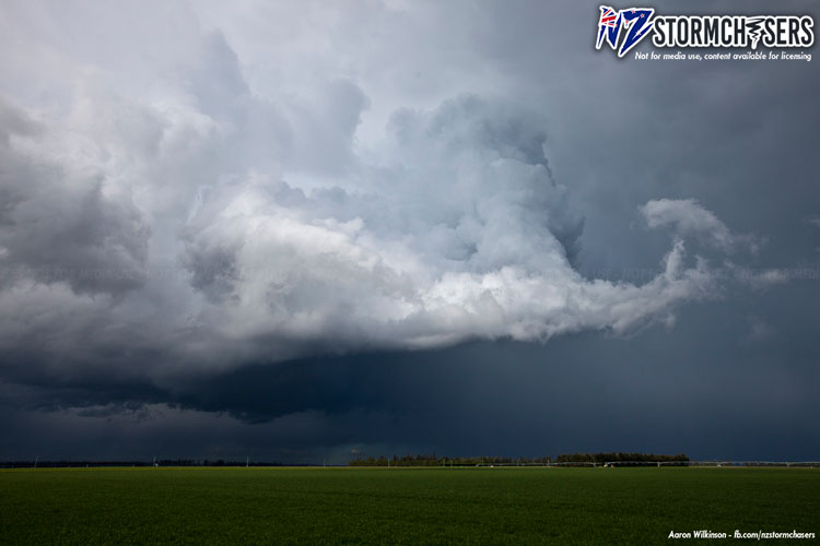
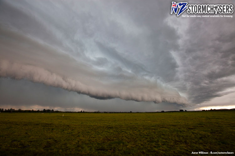
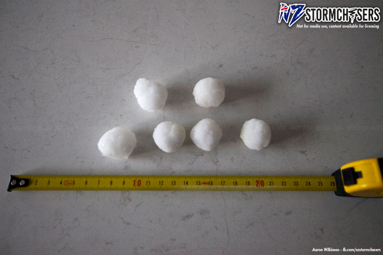
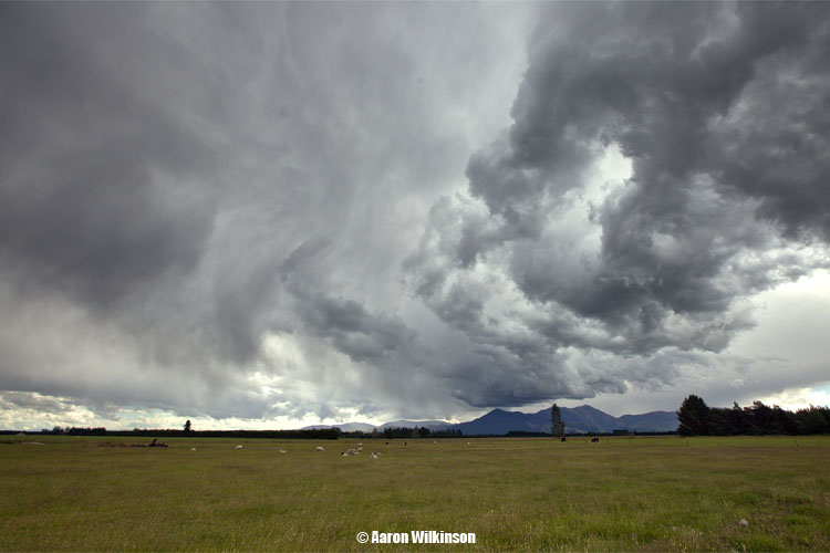
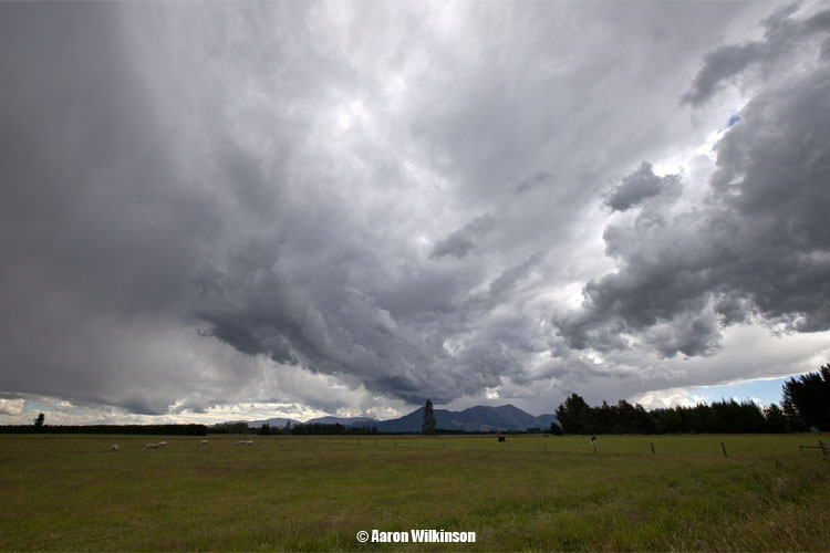
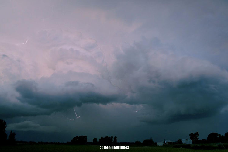
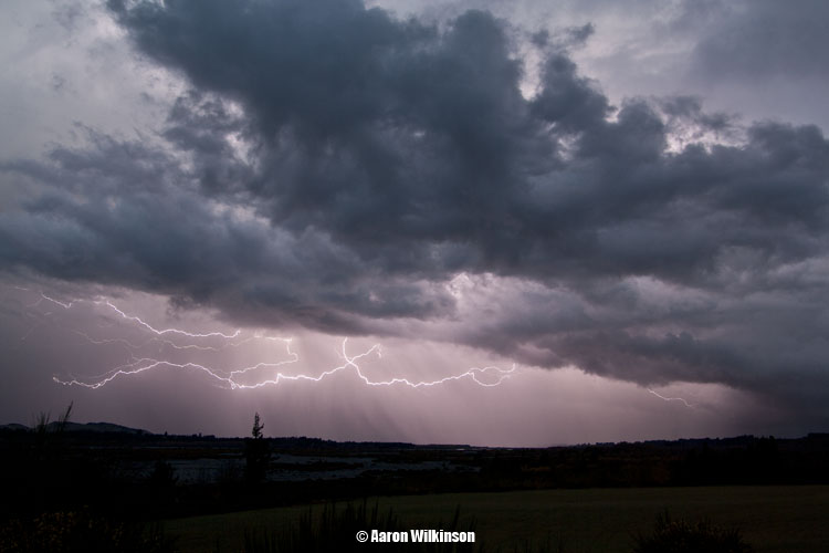
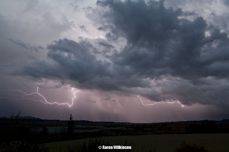
Naturally the following storm I do not remember everything but there were two cells this day. The first one was the better one in terms of lightning and hail and must have formed on a small trough (pre-frontal trough) ahead of the main southerly change which a second storm formed on. The first storm had some large hail associated with it as can be seen by the below photos, this hail fell around Mount Somers where I lived at the time. We saw rotation in the cloud too so perhaps a short lived super cell type situation. The second storm did have a nice gust front to it though.
I had some chaser convergence on the road and ran into Ben Rodriguez somewhere between Rakaia and Ashburton, Ben took a cool photo of me and took some great photos of the gust front! Fellow stormchasers.co.nz chaser Steven Burrows was out chasing also and took some photos plus made a video.
From memory I think we figured the main change / front would bring the best storms on this day but the first one on the trough line ended up being better. Something I’ve always remembered going forward about how the best storm could form ahead of the main change, but at the end of the day you assess where the sweet spot could be and then chase accordingly and do your best.
The first chase day of the new year and we get a tornado!
A couple of day’s out from this event Stephen and me looked at weather models and we saw there was a cold pool of air high up in the atmosphere floating over North Otago through to Mid Canterbury what looked like Thursday morning and just into early afternoon on the 3rd of January before it slipped away out to the east.
We thought things would have to develop fairly quickly for anything to get going as the unstable air appeared at first glance to not last all afternoon, although GFS was suggesting unstable conditions through to 7pm so that was good even though it modelled the upper air to get a bit warmer. Surface temperatures / moisture and good convergence must’ve been enough to overcome the cold air slipping away. Metservice were fairly confident also on their thunderstorm outlook that storms could occur late afternoon and into early evening before dying away, they also mentioned the possibility of a funnel cloud or tornado happening on this day so that worked out quite well.
I had to go out to Mount Somers on this day as I’ve just bought a place up there and had organised for the power to be hooked up on the 3rd of January. As there was a chance of storms also in South / Mid Canterbury the timing worked out well. We were up there by 1pm and nothing much had occurred but some development slowly trickled along as the afternoon progressed so we hung around.
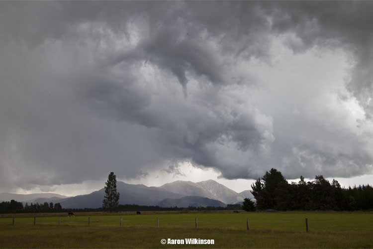
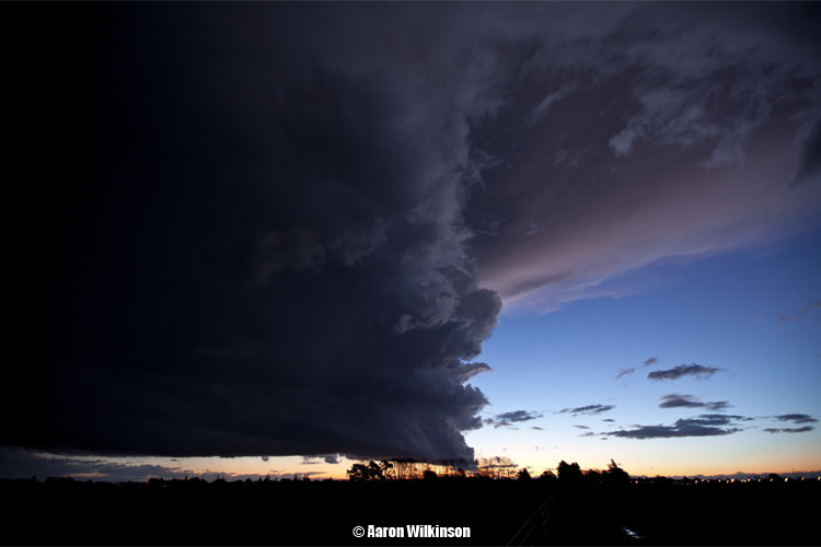
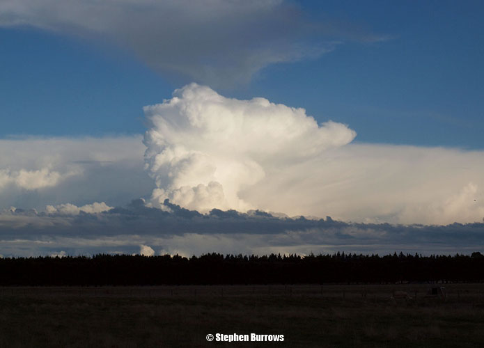
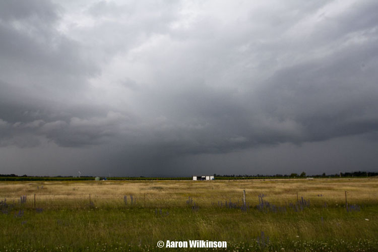
This was the sky eventually at 4.40pm as things started to look better.
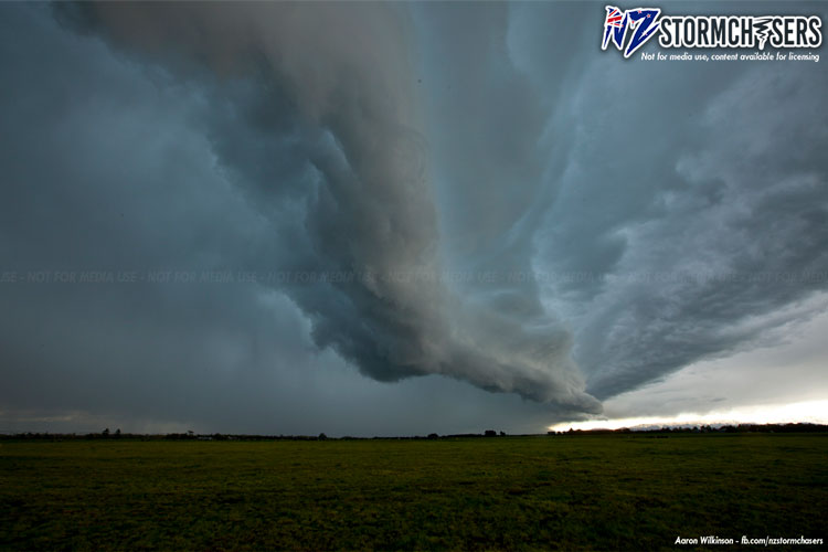
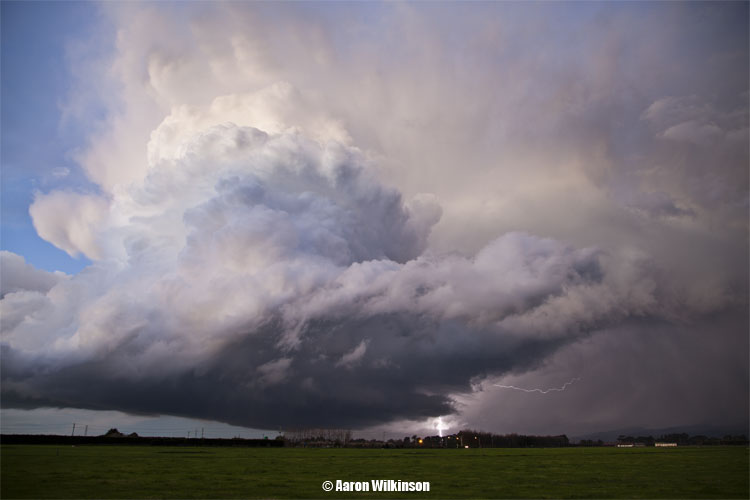
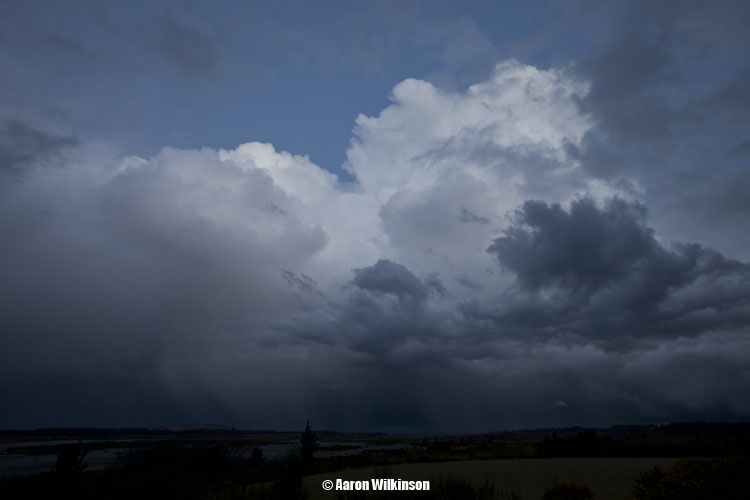
The old haunt thunderstorm corner started to look quite good at quarter past 5, thunderstorm corner being Mount Peel of course, aptly named by John Gaul for it’s higher frequency of thunderstorms occurring in that area then other places around Canterbury. An area of cumulus started shooting up to the right of us also and looked strong, even though at that stage it was just humble beginnings it would be something to keep an eye on.
A few strikes of lightning and big rolls of thunder were now coming from Mount Peel around 5.30pm and then our first funnel of the day developed, only small but definitely caused some excitement between us. As this funnel weakened there was actually another rope type funnel that seemed to come out of the same area but it was hard to photograph as it seemed to just blend in with the cloud behind it, it didn’t last long.
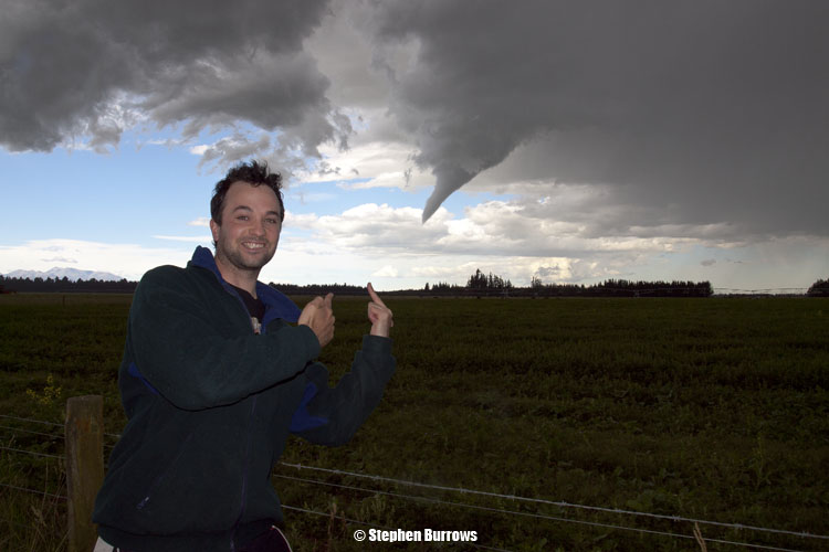
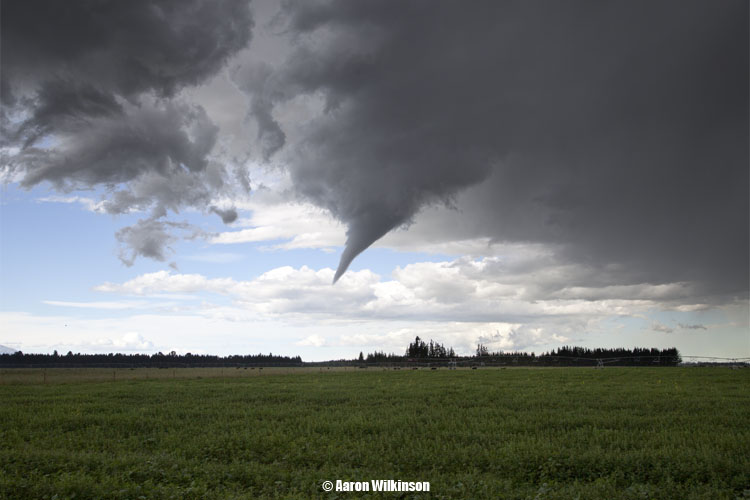
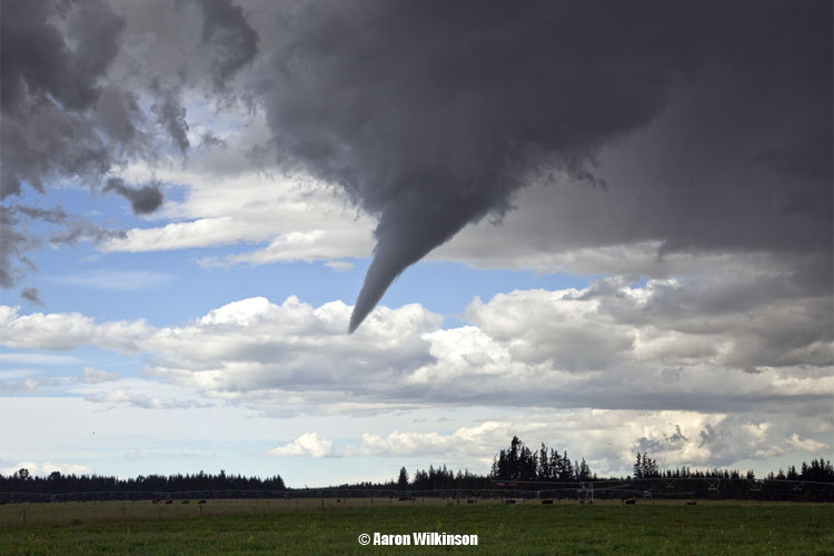
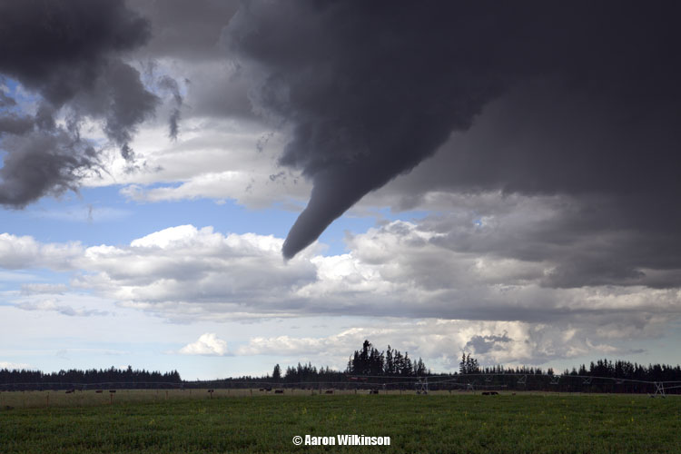
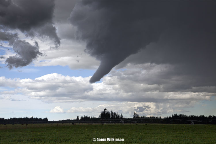
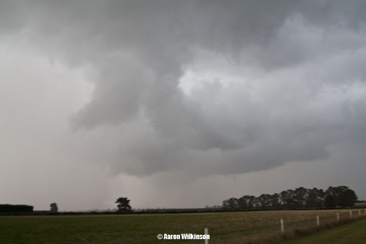
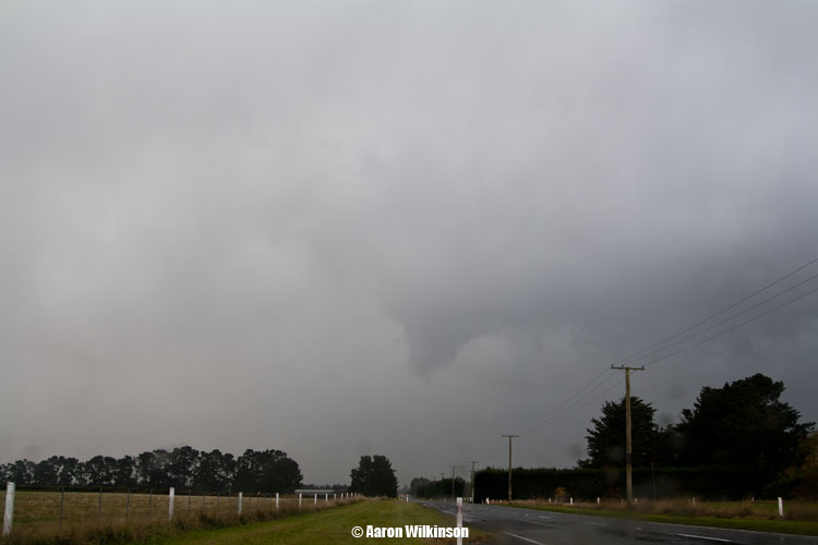
Then low and behold, the strongly developing cumulus to our right started to push out this scraggly lowering right infront of us at 5.50pm! This thing turned into a fairly nice funnel cloud and for a time turned into an actual tornado. It went over the small country town of Mayfield and touched down in the golf course there uprooting some big trees and tossing branches about. The condensation funnel never reached the ground however after seeing the news reports that came out later and seeing a zoomed in shot of one of my photo’s showing some debris / rotation at the surface we can therefore call this a tornado.
At the time we didn’t realise it had touched down so didn’t think to go and check for any possible damage, a lesson for next time to go and check this stuff out even if a funnel doesn’t look like it has touched down. Here’s some pic’s!
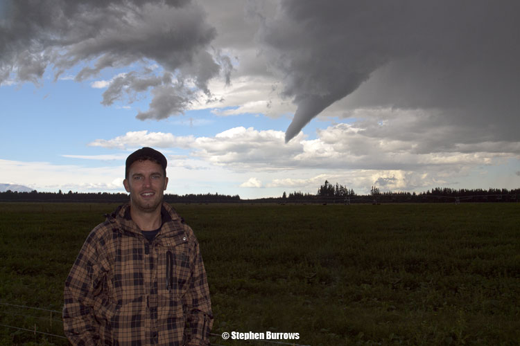
Even got a few typical chaser / funnel photo’s, would’ve helped it I was pointing more at it but oh well. Me on the left and Steve on the right.
This funnel / tornado lasted for just over half an hour which is pretty good going for a New Zealand based event of this type! There was actually a larger thunderstorm with possibly even a bigger funnel this day near Oamaru but doesn’t sound like it damaged anything so not many heard about it. Finally after this funnel got sucked up back into it’s attached cloud another funnel started up behind us although this one wasn’t as big and didn’t last too long much like the first, still pretty cool though. That made a total of 4 funnels for the day! Most I’ve ever seen in one day.
Now for some more good stuff. Stephen was videoing this whole event for us and it makes great watching, ok it’s not an American tornado that is ripping stuff out’ve the ground left right and centre but it is still excellent viewing considering this happened here in NZ. This video was even picked up by Reed Timmer from the famed Discovery Channel series “Storm Chasers”, Reed runs his own show now which can be seen at tvnweather.com, Stephen’s video was put up on tornadovideos.net via youtube. Make sure to watch it in HD!
It’s been a busy couple of days, is hard to find time in amongst work and other things to get a report compiled, the day I can earn something from this then I’ll be a bit quicker with updates. lol, but that seems unlikely, then again who knows……
As some may know I work part time at WeatherWatch.co.nz and in an article 6 days before this happened I wrote this.
“Early to mid next week it looks like there may be some cold upper air moving over the country so that could be a period to watch for some thundery development”.
That could be construed as a fairly general statement and it is but at least it shows you can define times a while in advance when you should be keeping an eye out for storms to happen, where they will actually happen is harder to figure out and can only be done a day or two beforehand (I have managed 4 days out though a few times) or on the day in question itself at times. On the Sunday before this happened I could see there was a chance on Tuesday evening in Canterbury more nearer the coast. Only thing though was it was early September and odds are that storms don’t normally start firing that early in the season so while there was a chance I factored that things possibly wouldn’t happen as we had barely got out of winter. Still, I was aware something could happen and kept it in mind.
Come the day in question, morning cloud and southwesterlies eased off and the sun came out, things were looking good. Isolated showers started developing on the ranges of Mid and North Canterbury due to heating and advancing cold upper air, I had work and while some of these showers did turn thundery I was more interested in the trough due late afternoon / evening so gave them a miss. I wrote a story at 2pm on this day and wrote this:
“Today we have cold upper air moving over the country in an unstable southwesterly airflow, this means there could well be some thunder and hail about especially in Canterbury later this afternoon and western parts of the North Island this evening.
Isolated heavy showers are already developing along the foothills from Mid Canterbury northwards through to the hills just behind Waipara and thunder has been heard east of Culverden in the last 20 minutes. This could be more of a prelude of things to come however.
The main southwesterly wind change associated with the trough is getting into Otago now with showers and the bulk of the activity will be associated with this change.”
That worked out pretty well for Christchurch late afternoon / evening as the city saw one of the best storms it had seen in ages, some were saying it was a once in 10 year event and in some ways yes but we did have a comparable thunderstorm on the 23rd April 2005 (click here for report) and on the 27th October 2002 we saw an even better storm then the one that has happened in this report. You could even say that on average a storm like this will occur every year or two somewhere in Canterbury, they just don’t always happen in the same place. On the 14th December 2009 a big storm passed near Methven and dropped an 80m wide tornado even.
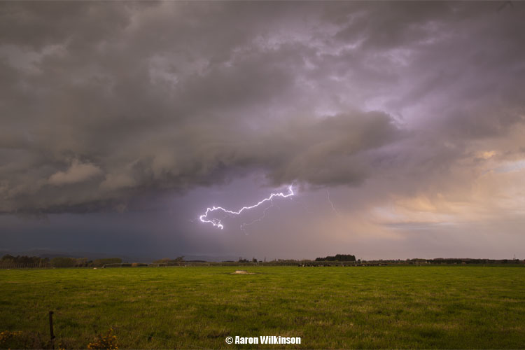
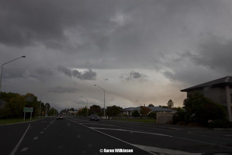
So enough writing and more details of the day. I chased with mate Mike Stewart after I convinced him something will happen, with the way things were developing on radar to the south around Rakaia I figured we won’t need to go far. Often when chasing I prefer to go with a country type landscape versus the city as I find photo’s have more artistic merit then cars and houses being in the frame, but that’s just my opinion. We ended up just southwest of Lincoln down Days Road I believe.
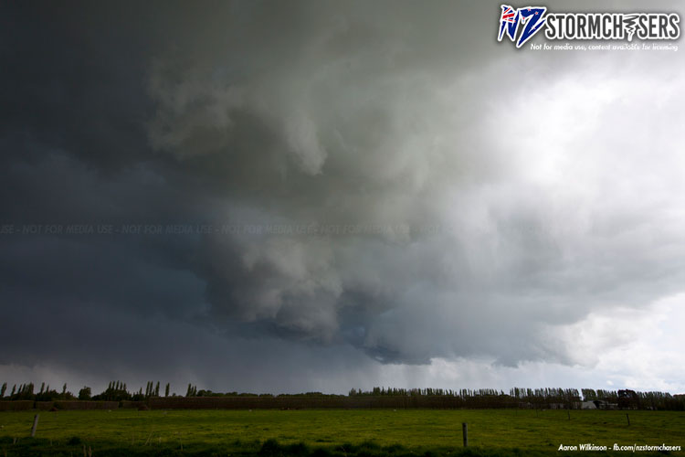
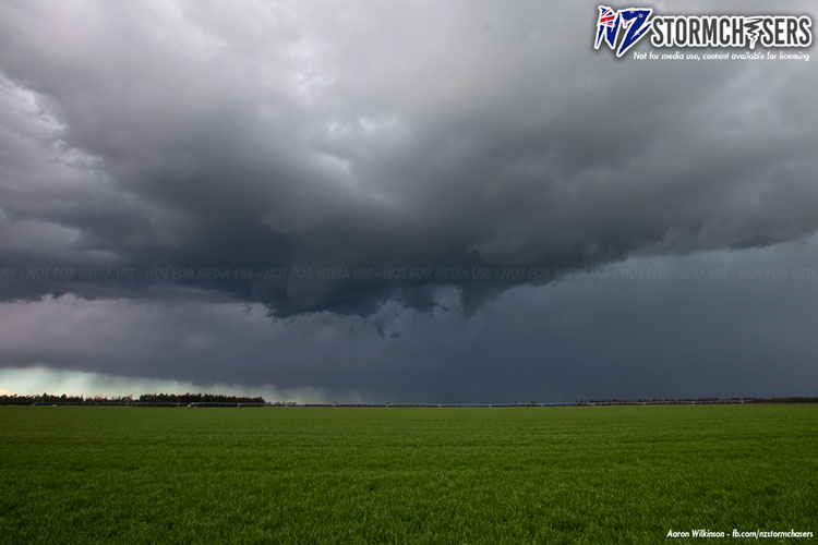
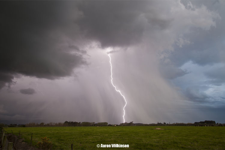
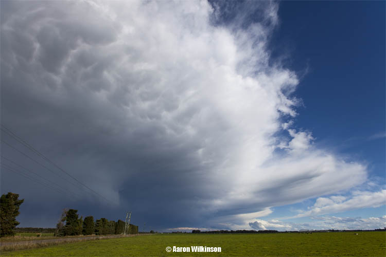
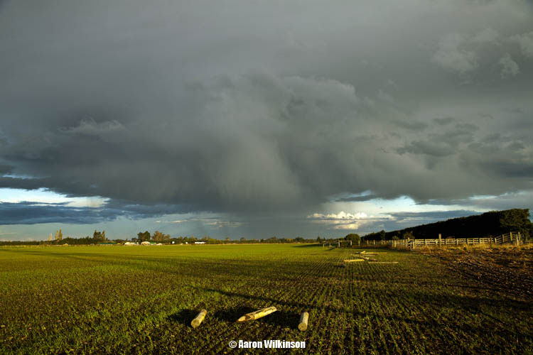
It slowly got darker and darker with everything developing right near us, couldn’t have got a better spot I believe. From studying the photo’s I can see the area that a mesocyclone formed started about 5.30pm which is indicated in the first photo below, the cylindrical shape in the image. The other lines are just rays of light coming in from the sun out west.
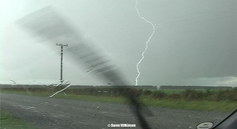
Then que lightning around the same time, unfortunately my lightning trigger wasn’t working properly so I didn’t get any lightning photo’s till about 20 minutes later. I had to trigger the shutter manually so I’m rather pleased with the amount of lightning photo’s I did end up getting using that method as it is more difficult, I could’ve even had more! Oh well. The rotating area is on the left hand side of the photo’s below.
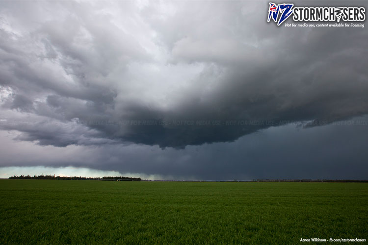
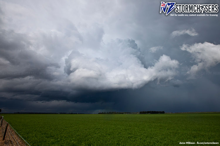
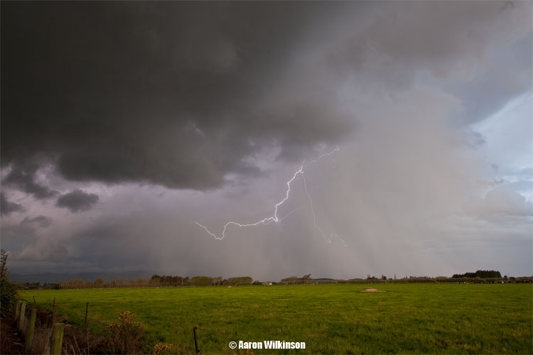
Then que more lightning images, the first photo below shows the meso looking a bit more defined at 5.56pm however after that it became a little more un organised. About 6.10pm it came together again and at 6.20pm it went right overhead of us with an area of rotation clearly visable. There could’ve been a funnel here but when looking strait up at it, it more or less just looked like a swirl. Good thing no tornado formed otherwise we would’ve had to move quick smart.
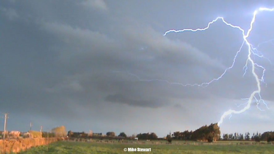
A lightning still from Mikey below.
A series of images from Ben Rodriguez below, fantastic lightning! Last image of his shows the rotating updraft in the left of the frame, you can see the banding cumulus forms twisting up. That is where we were right below when he took that photograph.
The swirling going on above us is in this video still below, it was definitely rotating. Could’ve been a funnel here but it’s hard to know when looking strait up at it like this, the thing was right above us! Reminds me very much of this day (click “here“) on the 16th October 2004, a funnel went right over us and it looked similar.
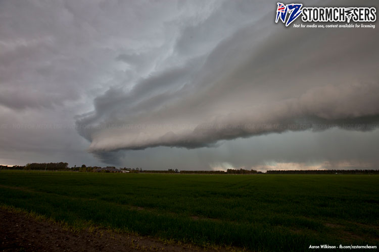
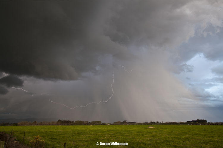
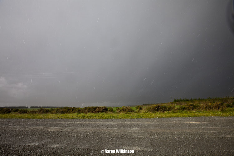
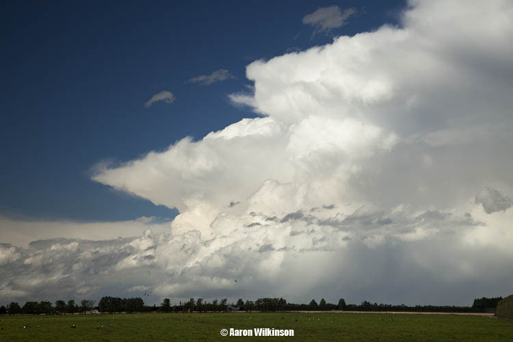
The first photograph below shows the storm when it moved over Christchurch city, it really started to unload at this point and literally golf ball sized hail fell in the city. The hail that fell near us was a slightly smaller offering at 10 to 15mm in size. Another cell formed and was coming up giving off some lightning strikes but unfortunately it died lightning wise as it got close.
All in all an amazing storm chase where we didn’t actually have to go that far from home. Every man and his dog has a camera these days so there was a plethora of images that came out after this storm had moved through, many were excellent though. I had work strait after this storm finished so had no time to review what I had gotten.
Our footage below and then the One News report by Alison Pugh on the event including a little bit from me! Yeah yeah I need a haircut and that’s already happened 😀 It was a good thing Mikey was recording with his video camera while out there as I was often busy with my SLR. You can see a time lapse from Ben Rodriguez who was also out and shows the spinning updraft in the left of the frame, we were right under that and explains the twirling skies we saw right above us. And a word of advice if you want a video camera to record lightning, get one with CCD’s and not CMOS sensors, rolling shutter issues with CMOS sensors causes horrible banding in the video which I find a bit annoying and ruins good footage.
Who would’ve thought, but another little storm chase for myself as we nearly get into winter! Well this time I didn’t really have to go very far so that was a nice change, got some great views to.
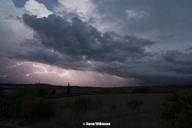
A very cold upper pool of air (-30 to -34 °C 500mb) was due to move over the South Island during Monday and with it bringing showers with a chance of hail, thunderstorms looked more likely to me say south of Timaru (which didn’t actually happen, cough cough). Steven Williams (NZStorm) on the New Zealand Weather Forum noted however on Sunday that he believed storms could form on the Mid and North Canterbury coast later on Monday, and when NZStorm says something thunderstorm wise I always take note as he has a vast knowledge of stormy type weather in New Zealand. Still it seemed like it might be difficult as I wondered with it being nearly winter there might just not be enough surface temperature and or moisture there to support storms, NZStorm was right though.
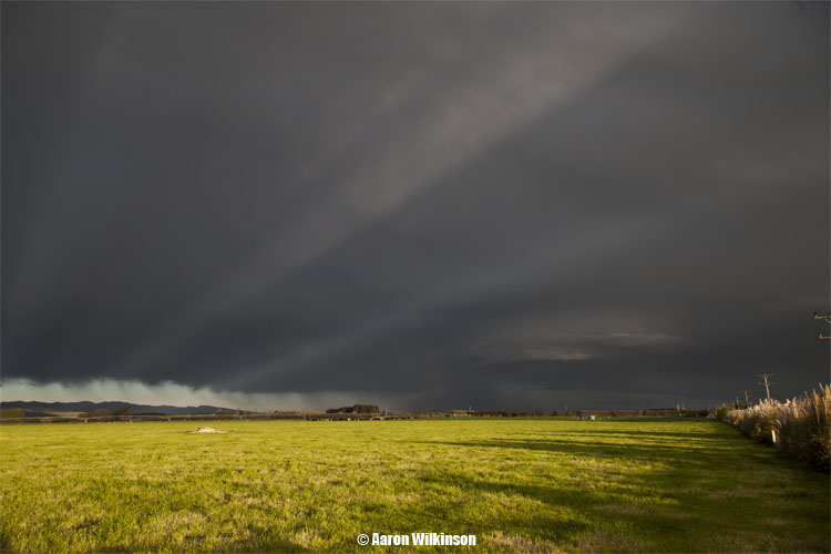
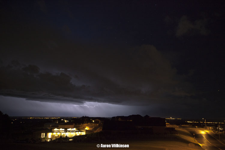
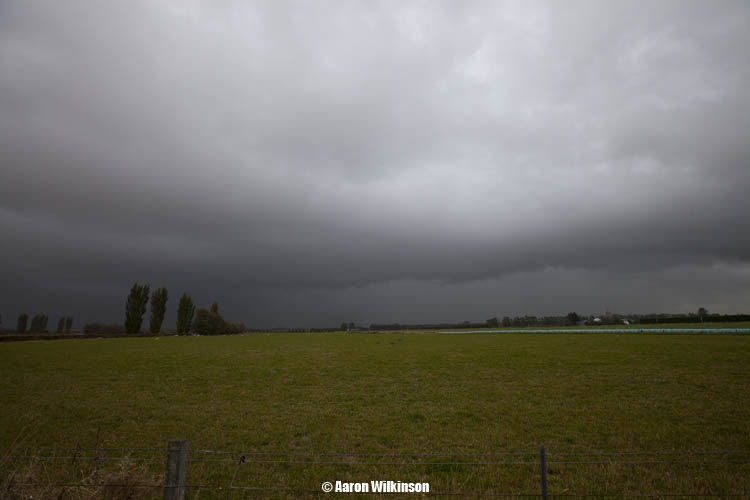
Around 4pm the clouds were looking unstable towards Banks Peninsula, so this showed some promise for the evening cold air.
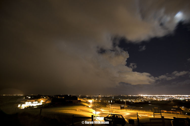
At 4.30pm a cell had started to come out of the Peel Forest area, why am I not surprised. Just before 5pm it became more organised and lightning started off in a line between Mayfield and Ashburton. I could’ve left home earlier but I was still a little weary if things would actually fire. Once I saw the strikes appear on the tracker I left from my place and by looking at the weather radars determined Birdlings Flat would once again be an ideal place to head to as the showers were moving in an angle towards that direction. Once I got some fuel in Halswell though the clouds looked threatening closer to where I was so I made a change of tack and went up to the top of Kennedys Bush Road instead. As it turns out that cell didn’t become active for that long, I took a photo of it as it approached Christchurch hoping for a rouge lightning bolt to pop out. Some small hail fell when it moved over around 6.30pm. The colours with the twilight in the distance looked quite cool!
Hopes were fading (gee that happens alot with these reports! lol) but I decided to stay up the top of the hill as this line of showers moved over and then cleared, Stephen Burrows was out on the Old West Coast road and we both were talking about a new line that started forming along the length of the Rakaia River on the Plains. We could see it on radar and it came into view in the twilight from my position. Then I saw a flash! With new hope and clearing skies lightning photography chances just went up!
This new line only became active for about 10 or maybe 15 minutes at most, lightning wasn’t overly frequent so I had to make the most of it. I didn’t get any nice big Cg’s unfortunately but got a few goodies. There is a plane moving across the sky in the 4th photo below, that’s the reason for the streak of light in the top left.
Just after 8pm the line was beginning to move over and it started showering again so couldn’t take photo’s anymore apart from inside the car, the cell wasn’t active anymore anyway so all good.
I waited some more but nothing else happened so headed home, on the way that new song with lightning in it started playing so made a small video clip. lol. I wanted to focus on photography versus trying to video at the same time hence I’ve got no video of lightning. I’ll have to get a second tripod set up with the video camera on it in future so I can just leave it running.
A large depression had been brewing in the Tasman Sea over the weekend and as it moved east over the country it then dragged up very cold air behind it in an associated southwesterly flow.
The west coasts of both Islands had been affected by thunderstorms the previous two days and more was to develop on the west coast of the North Island on Wednesday. Sitting here in Canterbury it was no fun watching other places get thunderstorms but you tend to accept it as we just don’t normally get thunderstorms in the colder months of the year. The day before this event occurred models were not showing any negative Li’s over Canterbury for Tuesday apart from off the coast, neither was there much CAPE. From memory I think the models were showing a small amount of CAPE but nothing worthy of note. The models would’ve been forecasting upper air temperatures fairly accurately but the surface conditions were a little different to what it was thinking I believe. The main ingredient being that surface moisture was a bit higher then it had anticipated. On Monday I saw that total totals were sitting at 55 over Canterbury for Tuesday, now this is quite good for thunderstorms. Only thing I was wondering is that surely storms won’t form this late in the season, and the fact that there would be a S to SW wind already flowing over Canterbury didn’t bode overly well either. However, as I woke up on Tuesday you could see it was quite sunny with nice cumulus clouds going up. Conditions were quite calm with the SW breeze only faint and the dewpoint was a bit higher then I originally thought it might be, immediately thunder chances just went up!
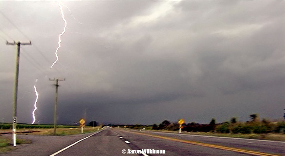
I could see a cell forming out of the Mount Peel area (surprise surprise) around 1pm so I got some gear together and headed out. Another check of the radar when I was further south and I could see it had moved near the Rakaia Gorge, surely enough this cell came into view so I knew where to head to. Scferics started flaring on the radio to so it was now active. I turned right and travelled along the northern side of the Rakaia River inland, on the way I noted a Cg come out of the cloud. Once there I saw a little bit more lightning as I set up but didn’t see much else apart from the dark cloud.
I was hoping I could do some lightning photography with my lightning trigger but low and behold the 9V battery in the thing was flat! Arghhh, this was no good. And I forgot my shutter trigger thingy, double arghhh. Still, if lightning went off later when it was darker I could just press the button on the camera and hope I was steady enough for a long exposure.
Stephen Burrows finished work and headed inland about 4pm to near Darfield, he took a nice photo of a Cb that was offshore to the SW. While things weren’t overly active it seemed like a dark heavy anvil was spreading northwards along the foothills coming out of this Rakaia Gorge cell. Steve noted it was looking good from his position so I made the decision to head towards him. On the way I pulled into Hororata and got a 9V battery at the garage there, thank goodness for that as it would come very much in handy! Scferics started going off again, I moved into position near Waddington about 6pm as the clouds looked good. Didn’t see any lightning but me and Steve both thought the sky did look a bit suspect with some twirly motions going on, a funnel looked to of developed for a time but we can’t be confident it was an actual funnel and not just a piece of cloud that looked like a funnel. It did last for a little while though and stayed the same roughly as it moved into the distance so maybe? Atmospheric wind conditions didn’t look likely to support tornadoes but small funnels can form out’ve any thunderstorm at times.
Steve was running out of fuel so we had to go back to Darfield to fill up. I went to the Waimak Gorge as I figured it would be a good place to photograph the clouds and any potential lightning that might happen. Big Cg’s started going off as I was on my way there so hoped that this was a good choice. It was a good thing I got that 9V battery as I needed it for my lightning trigger. I set up and got some great lightning strikes but no good Cg’s, also videoed aswell. In hindsight I might’ve been better placed back towards Darfield but oh well. In saying that when one blows up these images and turns it into a panorama they look pretty cool!
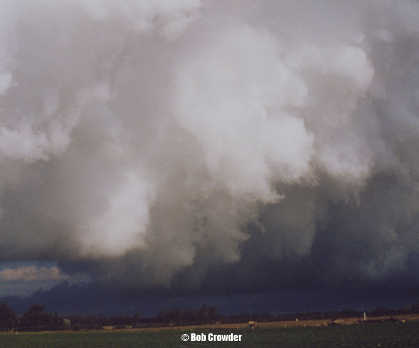
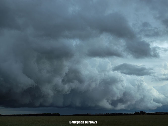
The cloud base where Steve was near Darfield looked really manky and dark, I could sort’ve see it from my position at the gorge and knew what he was on about. It reminded me and Steve of a cloud base that came from a storm Bob Crowder (New Zealand thunderstorm Society) went after back on 11th March 1999, this cloud produced a tornado near Ruapuna (Mayfield). Steve’s photo on the left, Bob’s on the right below.
A spectacular Cg photo was taken by Rob Dickinson near Darfield, you can see it here.
The lightning to my east / north was not firing anymore so I headed to the cell with the dark ragged base near Darfield as it was still going off. Saw an amazing Cg on the way there but unfortunately that was it and I didn’t see anymore close lightning for the rest of the night. A fair bit of hail had fallen around Darfield which made driving dangerous at speed, so one had to slow down. I met up with Steve to check the the radar and lightning tracker, we could see the storm was now moving offshore up along the coast. People in Kaikoura would’ve got some nice lightning that night aswell off the coast. We called it a day and went home, a great chase to start the beginning of winter!
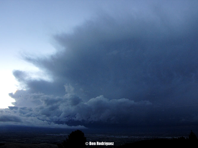
Ben Rodriguez was sitting up the top of Kennedys Bush Road in Halswell and got this shot of the Cumulonimbus cloud that was over me and Steve to the West around 6.20pm, a nice big dark cloud indeed!
The situation coming up looked likely to produce thunderstorms on the West Coast of the South Island (and they did happen there) but not until the Saturday morning before these storms happened on Sunday did it become clear that storms would likely develop on the East Coast aswell! Once this became apparent all systems were go for storm chasing possibilities in Canterbury. If storms are looking likely on the West Coast and East Coast on the same day I’ll take the East Coast storms anyday unless the setup for the west looks exceptional. Also later in the evening another opportunity presented itself with a strong cold southerly trough due to hit Banks Peninsula around 11pm.
I teamed up with Jason Tippet and Mike Stewart for this chase, Stephen Burrows was coming back from a weekend in Kaikoura and got the storm as it headed up near the coast at Birdlings Flat which is good as we were further south at that point in time.
We headed south along State Highway 1 around 2pm, storms look to of already developed in the Fairlie area so we would hope to intercept them around Ashburton as they moved north. Conditions were looking quite unstable just south of Christchurch, quite a few farmers were doing burnoffs and there were a few pyrocumulus forms about. Once near Dunsandel we could see the Cb anvil to the south of this developing storm, in Ashburton the skies started closing in. Saw an interesting spectacle I thought once in Ashubton, there was some burnoff smoke in the air and as a southerly wind change was moving through you could see it’s form because of the smoke. So if you’ve ever wanted to know what a wind change looks like and the boundary it develops then here you go!
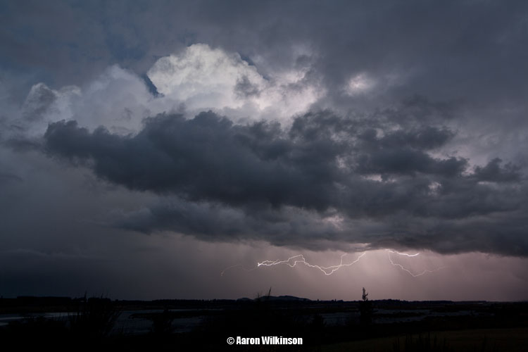
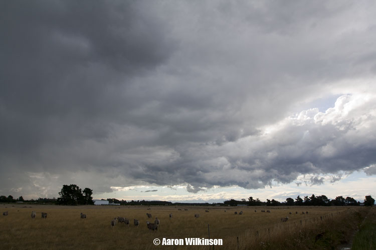
Looking at radar we could see this storm was very close just south of Tinwald where we went down Long Beach Road, fellow chaser Ben Rodriguez had already intercepted the storm near Orari with some big hail up to 20mm in diameter. The skies were looking black and lightning and thunder was going off to, I was mucking around alot with my photography gear trying to set up for lightning photographs but with the rain falling it made it very difficult and I got nothing in the end! You’ve got to try though I guess. As the rain started getting persistent we had to move and crossed onto the western side State Highway 1 where it looked dryer, once there around 3.35pm it started hailing however but it was awesome! Hail was probably around 10 or maybe 15mm in size at most and was hitting hard!
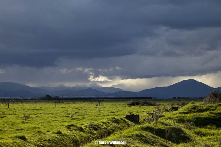
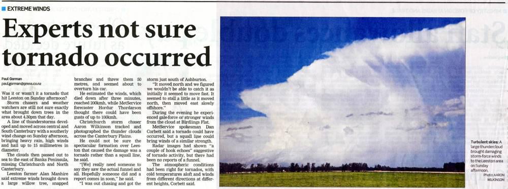
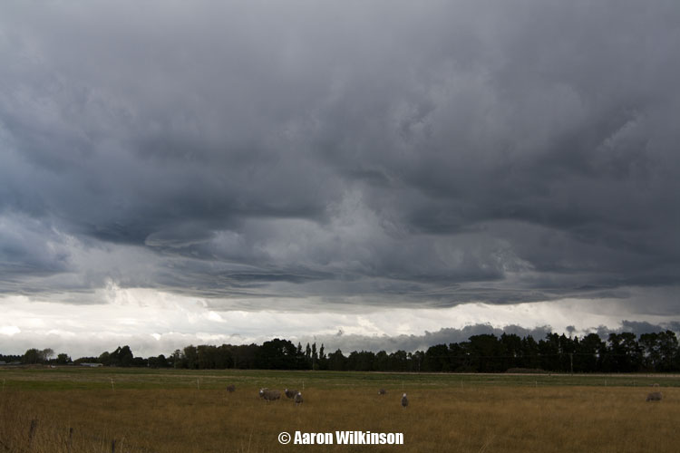
The hail seemed to clear fairly quickly and the cb seemed at first to be racing off north, it provided some great photo opportunities but for one reason or another we didn’t follow it strait away as figured it would be moving to fast to catch. In hindsight however we should’ve gone after it as it was the best storm of the day. It moved north fairly quickly then stalled before moving east offshore, this storm had some amazing strength and was still going off around 10pm at night way off the coast, you could see distant flashes of lightning coming from it! The storm also caused some damage to a farm in Leeston downing trees, it doesn’t look to of been a tornado but instead strait line winds perhaps. The third photo below I took appeared in The Press the following Tuesday with an article about the storm, I took that photo at about exactly the time the damage was caused in Leeston and it would’ve been right under those clouds. The second photo below I wonder if it might show some rotation due to the banding / circular nature of the main updraft on the right but I couldn’t be sure, Metservice did note that they saw a few hook echo’s on radar so maybe.
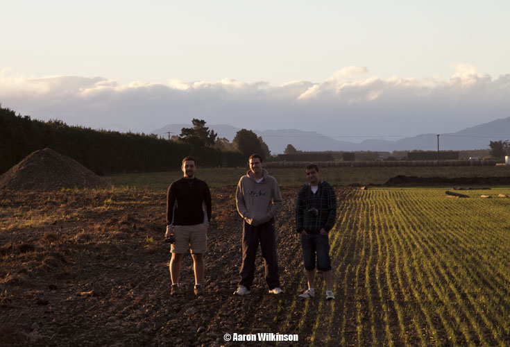
We decided to chill for a while in the same area, a small cell started to develop inland around 5.30pm. While not powerful it did look good with the various lighting conditions, it did produce a nice hail shower that we drove through. The now distant Cb from earlier was still there off the coast of Birdlings Flat and produced some amazing mammatus, best I’ve seen for a storm here. Wish I was closer to take a better photograph with the setting sun but oh well, one thing we were waiting on was the arrival of a trough that was to come up later in the day. Ben Rodriguez came and joined us in this spot for a bit, in the sixth photo below Ben is on the left, Mike in the middle and Jason on the right.
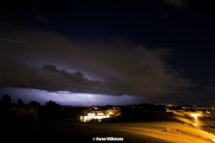
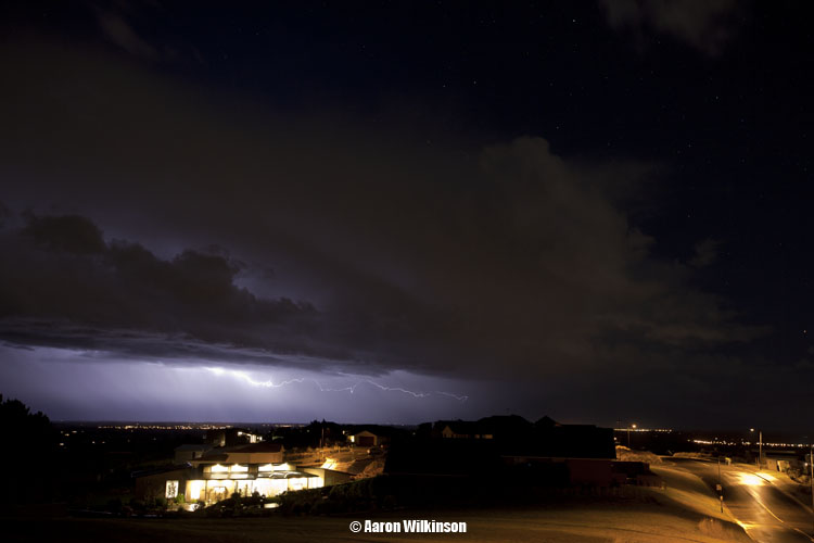
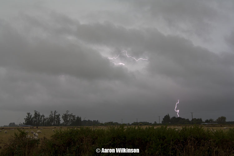
The long awaited trough was certainly taking it’s time, we decided to head northwards towards Banks Peninsula around 7.50pm and wait for it there. We saw the odd big flash occur from clouds offshore that kept spirits high that something would happen. Once at Birdlings you could still see the occasional flash coming from that original Cb of the day now way offshore to the east. The outline of the clouds to the south was hard to see with our eye’s so I took a few long exposures with my camera and cranked up the ISO to see what we could make out, even managed a shooting star! An approaching Cb looked ok, nothing special but we were hoping for just enough to get some lightning on camera. When the trough hit man was it strong, really had to brace yourself and try not to get blown over. Sea spray or rain was horizontal, I’m estimating winds would’ve been a strong gale perhaps bordering on storm force winds, 9 to 10 on the Beaufort scale. A few flashes of lightning did develop but nothing more really, there was literally only a couple of flashes and I didn’t manage to capture any with my DSLR, Mikey did with my video camera though so that was good. After we realised the action wouldn’t get any better we decided to head home around 11.30pm, what a long day but was alot of fun.
As I noted earlier Stephen Burrows got out after a weekend away in Kaikoura and caught up with the big Cb of the day around the Birdlings Flat area about 5pm, he managed to film a few great CG’s and saw some amazing mammatus as the storms anvil moved over. Here is a couple of photo’s and a lightning still from his video camera, superb! Stephen saw the area of cloud about Leeston from a distance that caused damage to a farm but noted it looked messy with hail falling, no tornado visible to him.
And finally the article that appeared in The Press the following Tuesday regarding this storm, thankyou to Paul Gorman and my Dad for scanning the article so I can put it up here.
This chase was a very quick one for me, it happened to develop right on evening only an hour and a half before I had to start work. If it had’ve developed just an hour or two earlier it would’ve made this chase so much better in my case, once again I was cringing at the timing of the southerly that came through and the fact I had to get to work. (I actually don’t mind my job but when storms come along I cringe! lol)
I could see potential on this day a few days leading up to it on weather models but it wasn’t clear cut, I was concerned about a pre frontal northwesterly airflow that was drying out the atmosphere before the change arrived. Kudos to Metservice for forecasting this one, they did a great job. A northwesterly did blow for most of the day and the air was dry but interestingly a pre frontal southerly shall we say developed about an hour before these storms moved through, the dewpoint shot up and then these storms moved through on a stronger southerly change. Not a situation I see to much here in Canterbury, normally once a southerly has come through you would expect storms on that front or the chances are over and you go home. Yes you can get storms on a trough after a southwesterly front has gone through but I’d normally expect a break in the weather before that would happen. So it was interesting but with the data available now through real time radar you could see what was happening and keep up with it.
I was hesitant to go too far from Christchurch because of the fact I had work, if I had of had my way I would’ve chase this storm from Mayfield through to Oxford. Large hail fell in Temuka on this day reported to be up to golf ball size, there is a story on stuff.co.nz here. Funny looking golf balls, the stones were definitely large but oddly shaped. People commonly say golf balls in reference to hail size but perhaps they were slightly smaller, who knows. So onto my chase story! I went just south of the Templeton area around 6.30pm and took some photos, I could see the thunderstorm line to the south was still a we way away on radar and I was unsure how quickly it would move north. I headed south anyway and got to about Burnham then took another look at the radar and saw the storm was moving inland, so made a beeline for Kirwee / Darfield.
Once west of Burnham I could see a line appear in the distance so I kept heading west. The radio was going berserk with plenty of scferics so things were exciting, but the time was 6.55pm. I had one hour and 5 minutes before work! Once in Kirwee I shot off the west coast road and onto a shingle road. I started seeing flashes coming from this line so began to film, got a few Cg’s on camera! I got to a spot around the intersection of Tramway and Boultons Road and set up for all of the 10 minutes that I was there, had no time really to think about composition or anything to add to a better photograph as it was also the first time I tried this snazzy lightning trigger I got given to me by Steven Graham, one of the first lightning bolts that struck out infront didn’t trigger the device and I got briefly frustrated so took of a shield around the sensor that was to help stop triggering the camera every time even the faintest flash went off. Unfortunately I think the shield made it much to directional. The thunder after that first flash was really loud as some lightning went off overhead aswell and gave me a bit of a fright I’ll tell ya! You can see in the video below. Overall I managed to get a few shots of day time lightning which is a first for me, nothing special but it’s something and my first go at using this device. Once it got to 7.30pm I had to go and head to work, luckily I packed my uniform in the car incase this would happen so I just headed strait for work. What a pain in the a$# having to leave a thunderstorm like that!! Oh well, gotta earn some money to get a better camera right?
Apologies about the swearing in the video below, I’ve “beeped” those parts out. I’m not normally like that but with all the excitement, it causes these situations.
This event looked quite possible about 4 or 5 days out by going through weather models. Very cold air (-28°C 500mb) was dragged over the South Island from an initial frontal zone, the surface wind did change southwesterly with this front in the morning but I was hoping it would die out in the afternoon and then give a clearance with some sun for a time which sort’ve happened. For a brief moment doubt did creep in as the southwesterly front and cloud / rain did seem to hang around a bit longer then I thought it would, I always seem to have a moment of doubt at times on storm days as thunderstorms need unique factors to come together for them to happen.
The southwesterly didn’t totally die out but it did ease a fair bit with the sun coming out around 5pm, then in the evening around 7pm a trough I was expecting came up with an invigorated south to southwesterly airflow delivering thunderstorms! And would you believe I was stuck at work……………Nooooooo!!!….. However! Luckily Steven Burrows was covering North Canterbury and Jason Tippet / Mike Stewart were covering areas west and south of Christchurch. Steve seemed to be in the best spot for these storms that moved through although Jason and Mikey did get to see some lightning going off. I was in the Spreydon area at the time of the storm and observed a flash or two and heard some thunder, the storm while not overly active above the city it did class as a thunderstorm and Christchurch itself hadn’t really seen a storm in ages. In the first photo below Steve actually observed a short lived funnel coming out of this small cumulus cloud near Kaiapoi while heading north, unfortunately he couldn’t get his camera out in time.
The next 5 shots here saw Steve just north of Rangiora, he observed a number of Cg’s here which he filmed. The third photo below shows a cloud base which Steve saw rotating, so that’s pretty cool! The last photo is looking south with some mammatus hanging out of the back of the Cb.
As the storm moved north Steve drove up towards Greta Valley and saw more lightning on the way, the storm did move quite quickly though and he decided to end the chase there. I was gutted being stuck at work but glad these guys got out there to see what was going on.
When looking at satellite images I saw a nice line of Cb’s off the coast of Westport develop about the time I finished work (8.30 – 9pm), I figured at the time it would be a fantastic chance to do some evening / night time lightning photography but no way could I get there. A month later I saw this (click here) image appear in a weather photo gallery run by Metservice, someone out there was thinking the same idea as me! Wicked shot Francis Carmine.
Very cold upper air was due to come over the South Island this evening (-27°C 500mb),
once again a key ingredient at times for thunderstorms. This combined
with a surface southwesterly wind change brought a risk of storms along
the South Islands east coast.
I went over to Mikey’s place to say we should go out and wait for
thunderstorms, they were always going to be very coastal so the Banks
Peninsula area is a good bet as it juts out and often catches these
storms as they move up the coast in certain situations. It acts as a
trigger to and causes orographic
lifting helping the storms as I believe it did this night. We also
called Jason Tippet out in Kaiapoi so he came out and met up with us,
once again don’t normally like to chase with that many but these guys
generally are always super keen to go after something so put the option
out there. Mikey took his own car however as he said he might go back if
things didn’t look like happening, unfortunate for him as he left and
things did happen! You have to have patience sometimes.
Steve went out in his car separately and sat nearer the Selwyn River
mouth like we did on the 18th November 2011. Jase, Mikey and me decided
to go for Birdlings Flat. There was a thunderstorm that had developed
just off the coast of Birdlings Flat a little earlier in the evening
around 7pm but we weren’t there then unfortunately arriving an hour or
so later. Once we arrived nothing looked terribly exciting, but I was
content to wait as a southwesterly change I was expecting hadn’t come
through yet. The evening colours on the hills produced by the setting
sun did look rather nice though.
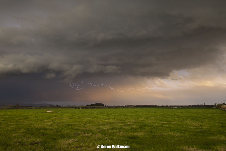
Around 9.30pm Mikey decided to go home as he wanted to have an early night with work in the morning, Steve sitting out near the Selwyn also decided to go home. Still, Jase and me were willing to wait longer. I turned on the AM radio not long after as a Cb offshore from Timaru at a guess came into view with areas of cloud clearing. Sferics started to fire on the radio so things were looking up, I was pretty confident it was this Cb we were looking at but it wasn’t dark enough yet to see any lightning. Not long after though we started to see a few flashes and little bolts coming out the bottom of the cloud! I set up my DSLR to see if I could capture a few of these flashes, a bit hard with there still being so much ambient light about. I would have to crank up the iso, open the aperture then hand trigger the shutter and hope I had enough speed to get a few of these suckers. Fortunately I did! Only little tiny lightning bolts but hey that’s pretty cool, a nice big positive Cg would’ve been nice but oh well. I got a little bit of video around this time aswell.
As things started to get dark the sferics died down and things weren’t looking very good. We actually started to head back towards Christchurch as even I thought it was over, on the way back before Motukarara Jason noted that some dark cloud edges were building outside to the south. Curious I pulled over and man he was right, we headed back towards Birdlings flat but didn’t go to far. I wanted to keep out of the rain to try and get some lightning photos, I can’t remember where we stopped exactly. I set up all excited as I am when these situations come upon me, lightning started going off and I tried to get some photographs. Unfortunately there weren’t any bolts coming out of the cloud, plenty of IC lightning (sheet lightning) but that was it. It didn’t last all that long either, the cloud quickly headed off over the Peninsula and that was our opportunity gone. I didn’t have time to video at this point as I was more concentrated on photography. Still I got 2 or 3 okish shots, here they are. Briefly the last 2 shots look ok but I’m not entirely happy with them, I won’t bother going over the technical jargon why. I had to play with the files to even get them looking like this so yeah they aren’t anything amazing in my view but it’s something that you guys can see here. The first shot I don’t mind, even if there isn’t any big bolts anywhere. You can also see the Southern Cross in this photo.
There is a car about to come around the corner in the third shot hence the bright light in the bottom right hand corner.
As it looked like it had come and gone we started heading home around 11.50pm. We noted distant flashes still coming from the cloud as it went into the distance but nothing we could make use of, I dropped Jason off at his car and headed back to my place. On the way I could see lightning flashes as it headed offshore, but now it was more visible having cleared Banks Peninsula slightly. I thought I should give it a shot and set up again at an overbridge close to home. Amazingly I got a few more lightning photo’s! Darn annoying moon was in the way though! Grr, or does it add to the image? You decided, I’m not a fan of it being there, distracts from the lightning! Nice with the city lights in the foreground though.
So all in all a bit of fun had on this chase. Moral of this story is be patient, and then when you think it’s time to give up be a little more patient!!
There always seems to be some factor with thunderstorms that could possibly ruin the chances of storms happening, this could be anything from low cloud cover, high cloud cover, a southerly coming through too late, not enough surface moisture or not enough surface temperature for example.
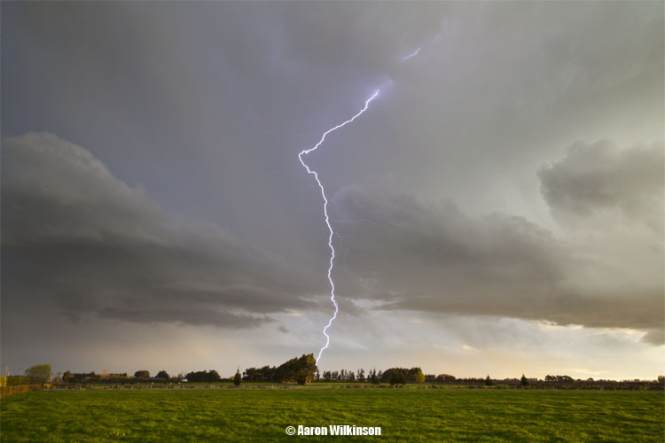
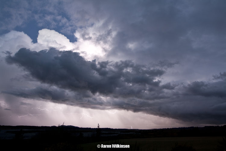
On this day the main thing I was worried about was high cloud cover hindering afternoon temperatures from rising enough, the upper air wasn’t particularly cold (-14°C at 500mb) but there was good surface moisture. I knew there was a risk of thunderstorms happening somewhere in North Canterbury most likely but stayed at home till I was sure things looked good. A look at the nrfa website for this day when data came out around 2pm showed good temperatures in the Amuri basin, this was quite positive. A look at satellite images showed a band of high cloud over the South Island running north to south which was just west of Amuri, another good sign as it let the sun in. I left a little bit later then I should have though, I think due to the trip we took to Springs Junction only 3 days before I was weary of going too far for not much perhaps but thinking about it I should’ve just shot off as soon as I saw development on the radar at 2pm! Oh well, I still got some good rumbles of thunder and saw some quite impressive Cg’s in the time I was out.
I left home about 2.50pm and headed pretty much the only way you can into North Canterbury, state highway 1 heading north! I was hoping to get into Amuri where this storm initially developed but didn’t end up going that far. I turned on the AM radio in the car south of Amberley and this storm was going nuts! Sferics going off constantly, while going through Amberley I saw a big Cg come out ahead of the storm which I don’t get to see to much with storms in Canterbury, my guess is big positive strikes! I got my video camera out and started recording, I didn’t see much till I got nearish Waipara when another big Cg came out of the cloud. Was awesome as I hadn’t really seen good lightning in quite a while!
I pulled over to the left down a side road and set up just south of Waipara. Took some photographs and heard some thunder, I wasn’t there to long as rain started falling 10 minutes later so I had to start moving back south again. While there though a big Cg went off which would’ve been only 1km away at the most, the sound of the thunder cracked big time and was wicked!! You can here and see it below in the video, at first I thought I just missed this lightning bolt on the video camera but while editing the clip for this report realised I’d just caught it!! Yikes is all I can say! The video stills for both strikes below, touched up a bit.
When the rain started to fall I headed south and got back to Amberley, I sat there for a while and heard a few more rumbles of thunder but that was it pretty much. The storm slowly lost it’s punch.
I met up with Steve in Saltwater Creek as he left strait after work but unfortunately he was too late by that stage, we thought the clouds looked promising at times but no more was to happen. A quick chase but the thunder was pretty cool!
I got a txt from a friend Richard who lives in the Amuri area at 4pm regarding the storm around 3pm, he said “Just had a massive storm, 47mm in 1 hour! But lightning hit our internet dish! Non stop thunder too!”. So it certainly must’ve been exciting times in Amuri that day!
Things were getting serious with hardly any thunderstorm opportunities in Canterbury, we would have to start looking further afield to feed our hunger.
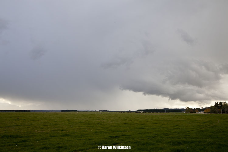
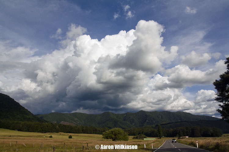
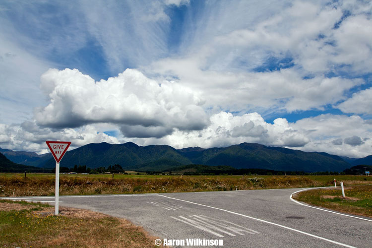
A slack pressure gradient was sitting over the South Island, looking at weather models inland areas of the upper South Island showed promise with good low level moisture and convergence. Warm afternoon temperatures would turn the atmosphere unstable. A brief summary of this day to us was that we didn’t encounter any storms, they were a little further to the east from our position between Springs Junction and Murchison in an area where the roading network is not very good so it made it hard going to get any storms really. It was still a fun day out though with friends seeing the sights. Got some nice photographs to so thought I’d put something up to keep the content flowing on this site.
On this trip we had Steve, Jason Tippet, Mike Stewart and myself. We left Christchurch around 11am heading north, our aim to get to Springs Junction then go further north if things looked good. Conditions were nice and warm once we got to Springs Junction about 2pm and cumulus clouds appeared over the hills.
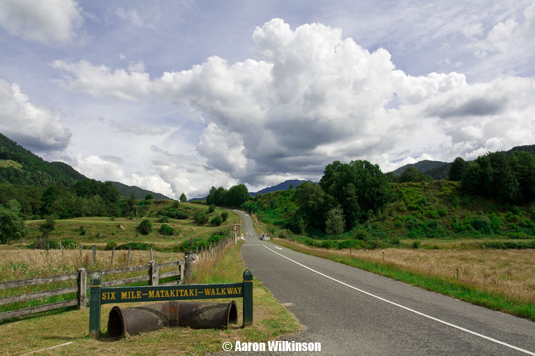
While interesting we headed further north to Murchison and down the Matakitaki valley, we saw a nice looking cloud brew up and get big but it moved to the east where we couldn’t get to. While there we found this neat little power station called “Six Mile”. Didn’t know this place existed but it is a hydro electric power station that was opened in 1922 and kept running all the way through to 1975, neat little place and just shows what you can discover if you get out there.
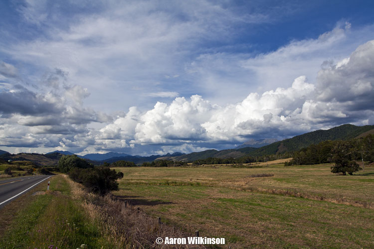
It was now nearing 5.30pm so we started to head back, on the way clouds looked good around Maruia so we stopped for a while and I took some further photographs of cumulus congestus over the hills.
We started to head back to Christchurch around 7pm, we should’ve hung around atleast an hour longer as these clouds going by radar and satellite pictures look to of grown bigger and pushed into this area. Whether there was any lightning I’m not sure of, the weatherzone lightning overlay didn’t show anything in this area around 8pm. It won’t pick up everything so if anything did happen it would’ve been quite limited perhaps. I’m a little perplexed as to why we had left, after the long day maybe we were all ready to go? I think if I was sitting there by myself I would’ve been content to just sit back and relax while the evening wore on, I might do that next time provided I don’t have other commitments. It was cheaper going as a group though even I’ll admit, $25 each for the return trip. Good value for a day out sight seeing, who knows…. maybe next time we’ll actually get some storms??


