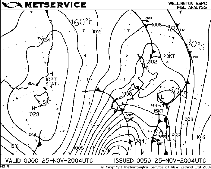
I was aware that thunderstorms could develop on this particular
Thursday and the morning looked promising …….however, a cloud band
moved over the South Island keeping things pretty dim and not thundery
looking at all. I could see in various models and satellite
pictures the cloud band moving north but I wasn’t sure how long after
the cloud band moved over that a southerly forecast was due. Lucky when
the cloud band moved off there was a nearly two hour period of sun
which made the temp go over the morning’s max so things began to look
good. The rain that fell from the band that moved over the SI provided
some needed moisture from evaporation as the sun was in the western sky
(dewpoint went from 5/6C to 8C when the sun came out). I was getting
excited at around 6:45pm as I spotted the edge of a large roll cloud
south of Christchurch, something had to happen!!! The models weren’t
showing any negative LI’s and CAPE was zero! It just shows that
sometimes they don’t get it right but they can be of use on other days.
I find upper temps tend to be fairly accurate though with models.
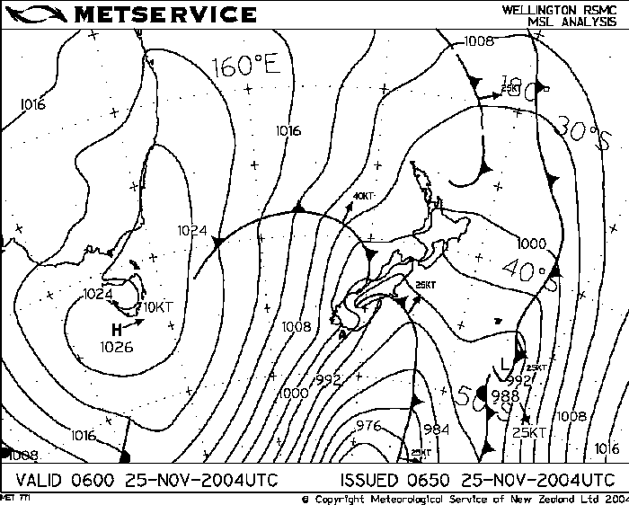
Despite the surface temp only getting to around 14.8 C in the afternoon
it was just enough as the upper air was quite cold, this with a
northeasterly before the change provided a nice afternoon of storms.
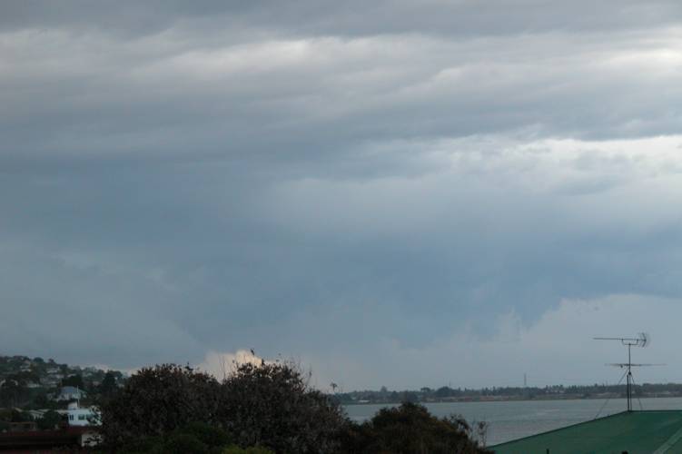
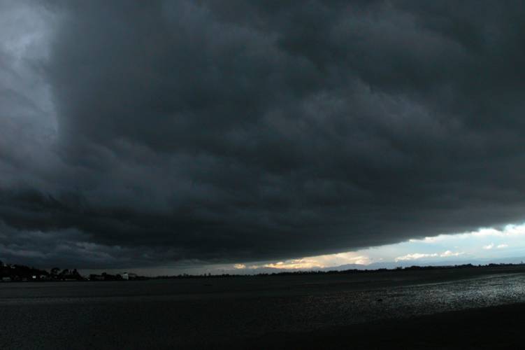
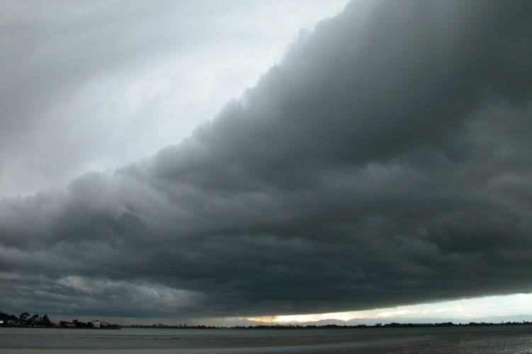
On the way home I took a photo near the Avon river mouth so I could get a
record of this beast of a roll cloud I could see in the distance, I
couldn’t see it in it’s completeness due to other cloud but I knew it
was big. Back in the car again and off home. When I got home I quickly
went to check the tracker and saw numerous strikes just south of Chch,
it wasn’t hugely intense but no doubt there would’ve been some nice
strikes out there. Dam excited I rang Steve to see what he was doing,
he was in Tai Tapu!! I said “What are you doing there?, and what do I
hear next! “Aaron, I saw a funnel cloud!”, trying not to pop, “What!!
Holy molly” is all I can say. Unfortunately he couldn’t photograph it as
it disappeared quite quickly. Where I was didn’t really turn out to be
that bad after all, pretty good infact. Winds were pretty uniform
throughout the atmosphere going SW pretty much all the way up to 300mb,
shear was good and storms would move at a good pace. The funnel Steve
saw would’ve been a localised type development and not part of a
mesocylcone.
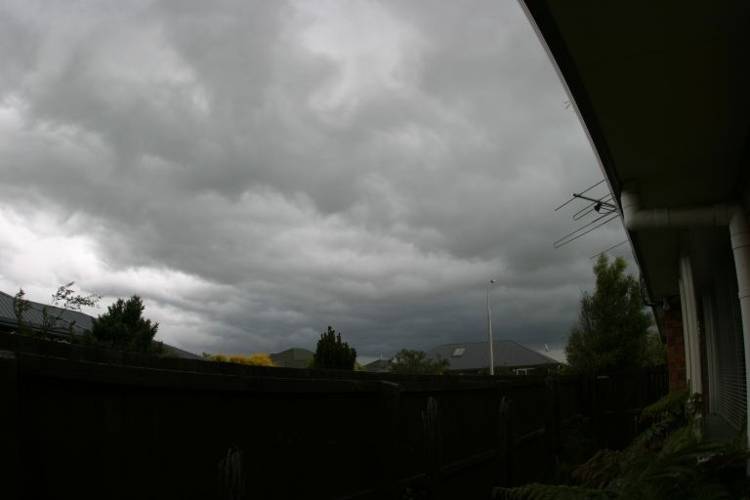
I jumped up on the roof and took some photos before running down to the
estuary to take more photographs. The base of the cloud over
Christchurch was looking quite turbulent and lumpy.
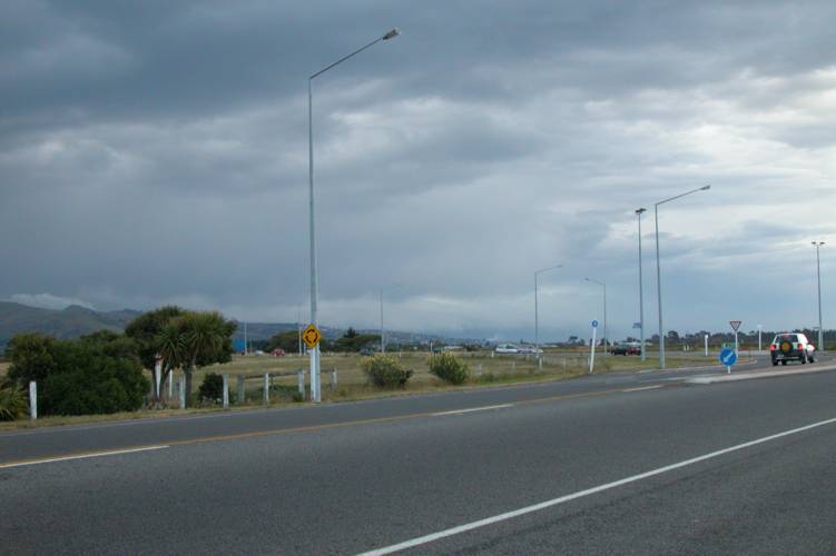
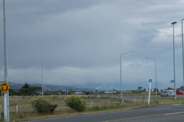
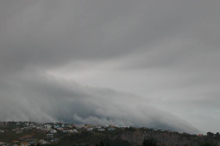
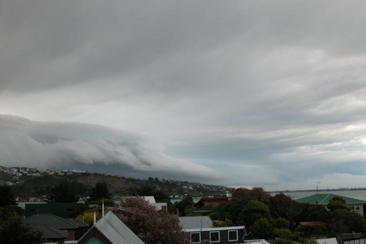
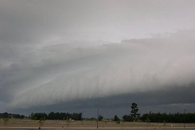
Donning my jersey and jacket and with all my camera gear under my arms I ran off towards the estuary. On arrival things looked impressive and organised with the front peeling over the top of the Port Hills in an arc over towards Christchurch and onto the Canterbury Plains. I was too close to be able to do a panorama but I got some ok shots. I got a drop or two on the lens at one point which is always a worry and can ruin a good shot, this happened to a couple of my photo’s and one of the ones you’ll see up on here. I figured it still looks good so is worthy of being on the site!

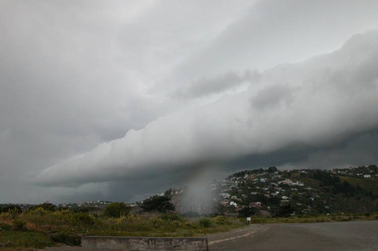
As this structure came over it got dark and very windy but no rain was falling as of yet. The underneath of the roll cloud was quite messy looking and not as nice as the front of it, I still hadn’t seen any lightning or heard any thunder. I couldn’t see any rotations of funnel cloud type matter so it was unlikely anything would happen in that department where I was and nothing did. The roll cloud as it steamed off looked quite impressive though, it looked very much disconnected from the Cb itself but was a great feature visually of the storm!


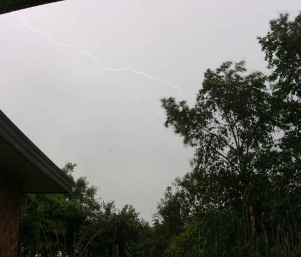
Steven Graham in Templeton got a few shots and did notice twirling motions in the clouds and took some photos and managed a lightning strike on his digital SLR camera, here’s a description from Steven.
“When the lightning was overhead, I noticed there was a bright stroke in one direction often followed by another going the other way. It was just luck that I was quick enough on the shutter release cable to capture this one after a number of attempts 🙂 I used ISO100 setting and f8 to increase the exposure time to 1/5 second which helped.” Here’s what he had to say on the NZ weather forum:
“Started seeing distant lightning and hearing thunder to the SW at about 7:15 but then it died out. After that several lines of cloud started to develop overhead. There had been a moderate ENE-E wind most of the afternoon and the southerly had just arrived. There were quite a few potential funnel clouds with the bases of the cloud lines starting to rotate and descend but nothing got too far before the gusty southerly wiped it out. I recorded some footage on video and you can kinda see what I mean from the first photo. The thunderstorm then developed with lots of long ICs running back and forth across the sky – no wonder the Boltek was confused.”
The Boltek Steven mentions is his lightning detector which you can view here.
As the roll cloud moved further north Jason Tippet was ready to have his turn for some photo’s of the roll cloud. Meanwhile I quickly ran home as it was beginning to rain but when I got home it sort of stopped with only a few spits hear and there so I ran back to the estuary again. As the Cb situated itself over Christchurch with no base visible probably due to rain things didn’t look great at all. I waited and then “Strike!”, I could see a nice Cg come down to the west of the city or perhaps somewhere in it? I then waited and some nice thunder came across, it wasn’t very loud as it was far away but sounded great. Lightning ended up not being that frequent with myself only seeing 5 or 6 strikes all up, the main lightning activity seemed to be just SW of Chch in a line from SE to NW. Only infrequent strikes really made it more further north.Where I was I didn’t get any hail but some was bound to fall somewhere.
There was hail out near Rangiora where Pam Johnson was driving home to Sefton when she had a big hail shower and saw lots of lightning:
“I left a job in Rangiora about 8.15pm and it was just starting to rain, then there was a really good hailstorm with quite large stones about the size of large peas, I stopped to see if there was going to be a photo opportunity but it was too wet and cold and I wasn’t dressed for the weather. The hail was the loudest I have heard on my car, I did think it would dent it. Then when I got to Sefton I ran into hail again.”
The last lightning bolt I saw was probably only a kilometer or two away from me, it was very bright and thunder sounded within a second or two very loudly which made the ground shake and me think it’s time to go! The wind was very strong and gusty with it getting cold, rain was also beginning to fall harder than before. I didn’t go along the estuary front not to be too exposed and didn’t want to get struck so just went through the scrub and tress behind me, my feet and pants got soaked but that didn’t worry me. That was actually the last bolt I heard or saw for this storm in the end.

As Steve was chasing the storm north he didn’t see all that much lightning either and got to around New Brighton from where he was in Templeton when he decided to go north. So he came over to my house and we reviewed the evening and looked at some photos I took.
As the storm moved north Jason Tippet got some nice shots from Kaiapoi.

It’s been quite a stormy period lately, so cool! Two funnel clouds sighted so far this season in Canterbury, awesome!!